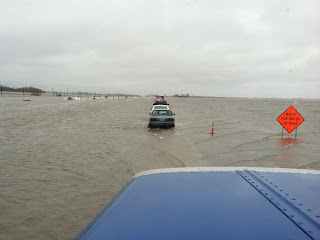
This is I 29 North of Fargo ND
There are hundreds of little communities and farms between here and Fargo that Have been cut off of everything. And the sad thing is this happens to some extent year after year after year! Last year we travelled to Chicago around this time of the year, and although the Red was high, there was no flooding - this year is a totally different scenario. Farms, small communities and homes in out-lying areas of larger cities like Fargo, Grand Forks and Winnipeg have been evacuated due to flood waters.
It is expected that the Red will crest here in about 2 weeks time. Sand bagging has been going on for weeks now, and still there is not enough.
I 29 between Fargo and Grand Forks.
Winnipeg is lucky to have a flood way. In the 1960's The flood way was designed and built around the entire city. It is basically a large ditch with gates, and when the Red gets high enough they open the gates and the water is diverted around the the city. Sadly the communities around the city pay the huge price for keeping the city dry. It's a on-going battle that I don't think will ever been settled, because when it comes down to it - no one can tame the Red.
Winnipeg also has the Assiniboine River running through it, which currently is over it's lower bank and it gaining control of the upper banks. I live about 2 blocks from this river, and although it is not the threat that the Red is, it still has the potential for a lot of damage locally.
Our friends Bill and Deb and their family have been evacuated from their home in Fargo. I wish them well, and hope and pray that their home will remain safe. My thoughts and prayers go with everyone who is dealing with this monster. Lets hope the flood waters recede quickly and damage is kept to a minimum this time. Stay safe everyone.


No comments:
Post a Comment